Solar System Scale Map Instructions
Create a true-scale solar system model on a real-world map. Use it for classroom lessons, public outreach, STEM events, and guided solar system walks.
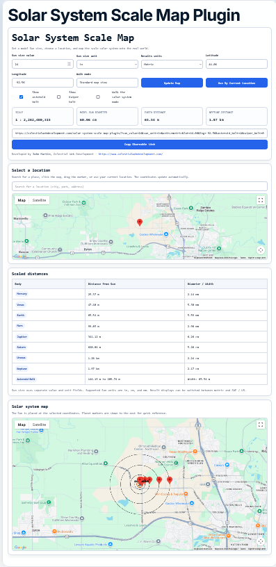
Interactive Solar System Scale Map
The tool lets users enter a model Sun size, choose a location, and see planetary distances translated into real-world map distances
.
Education Focus: The goal is to make the scale of the solar system understandable by placing it into familiar real-world locations.
Key Features
Real-World Map
Places the Sun and planets on a familiar map interface.
Custom Sun Size
Change the model Sun size and the entire solar system scale updates automatically.
Walk Mode
Generates a walking route with planet stops placed at scaled distances.
Asteroid Belt
Optionally include the asteroid belt between Mars and Jupiter.
Shareable Links
Save or share a configured solar system map.
Printable Outputs
Create field-ready printouts for presentations or solar system walks.
How to Use the Tool
Inputs and Buttons
- Sun size value: The size of your model Sun.
- Sun size unit: Choose inches, centimeters, or millimeters.
- Results units: Display results in Metric or SAE / US units.
- Latitude / Longitude: The location where the Sun is placed.
- Destination latitude / longitude: Optional endpoint for walk mode.
- Show asteroid belt: Adds the asteroid belt to the scale model.
- Walk the solar system mode: Generates a real walking route.
- Update Map: Recalculates and redraws the map.
- Use My Current Location: Places the Sun at your current location.
- Set Destination on Map: Lets you choose where the walk should head.
- Clear Destination: Removes the custom destination.
Tip: For public outreach, try a 24-inch Sun. It creates a dramatic but still understandable scale model.
Understanding Each Section
Scale Summary
Shows the calculated scale, model Sun diameter, Earth distance, and Neptune distance.
Scaled Distances
Lists each planet’s distance from the Sun, model size, walking time, and estimated steps.
Solar System Map
Displays the map with planet markers and, in walk mode, the route.
Walk Summary
Lists each stop in order for use during an actual solar system walk.
Using It for Education
This tool is ideal for demonstrating how far apart planets really are. Students and visitors can compare the compact inner solar system with the much larger spacing of the outer planets.
- Ask participants to estimate where Earth or Jupiter should be before revealing the map.
- Compare planet sizes with their distances.
- Discuss why most of the solar system is empty space.
- Use the asteroid belt to explain regions of the solar system, not just planets.
Using It for a Solar System Walk
- Enter the model Sun size.
- Choose the starting location for the Sun.
- Turn on Walk the solar system mode.
- Optionally set a destination on the map.
- Click Update Map.
- Use the walk summary and printed map during the event.
Field Use: Print the map and walk summary before the event, then use the QR code to reopen the live version on a phone.
Changing the Walk Location
You can change the solar system walk by choosing a new Sun location.
- Search for a new place.
- Click a new location on the map.
- Use your current location.
- Drag or update the latitude and longitude values.
After changing the location, click Update Map. The scale distances remain the same, but the real-world placement and route are recalculated.
Print Outputs
Print Summary
This output is designed for a compact reference sheet. It includes the scale summary, scaled distances, and walk summary without requiring the full map.
Print Map + Summary
This output is best for leading a solar system walk. It includes the real-world map, route, planet markers, QR code, and walk summary.
Using the QR Code
The QR code allows participants or presenters to reopen the same map on a mobile device. This is useful if the printed map is not enough for navigation.
Recommended for Outreach: Use Print Map + Summary for the walk leader and Print Summary for participants.
Ready to Try It?
Create your own scale solar system map and see how large the solar system becomes when placed into the real world.